Step Beat: Anthony and Ivondale

intersection of Anthony Street and Ivondale Street city steps, Pittsburgh, PA

Anthony and Ivondale streets, The Run

They’re not the longest or the prettiest. They’re not one of the great nature-in-the-city hikes, and there’s not much of a view. Heck, these steps don’t even fulfill the most basic purpose of infrastructure: you can’t go anywhere on them!

So why are we even reporting on the Anthony and Ivondale city steps? Well, this blogger will tell you. There’s a time for greatest hits and, as Buck Dharma so wisely reminds us, there’s a time to play B-sides. On the back of the platter, Anthony and Ivondale still earn the occasional spin, and it still sounds…er, walks pretty good.

The onion domes of St. John Chrysostom Byzantine from the Anthony/Ivondale intersection, Pittsburgh, PA

The onion domes of St. John Chrysostom Byzantine from the Anthony/Ivondale intersection

Last year we reported on the wonderful existence of the great Romeo & Frazier intersection in an overgrown hillside of South Oakland. That particular confluence of city steps is remarkable for a number of reasons, not the least of which is Pittsburgh’s commitment (at least, historically) to pedestrian thoroughfares as fully-accredited “streets.”

We see the same great treatment at the corner of Anthony and Ivondale, where the steps are given their own street light and signage. Only here, the whole enterprise is more absurd since there’s not really any chance of either walking these steps in the dark or needing directions to where they’re (not) going.

intersection of Anthony Street and Ivondale Street city steps, Pittsburgh, PA

Looking up Ivondale Street from behind St. John’s

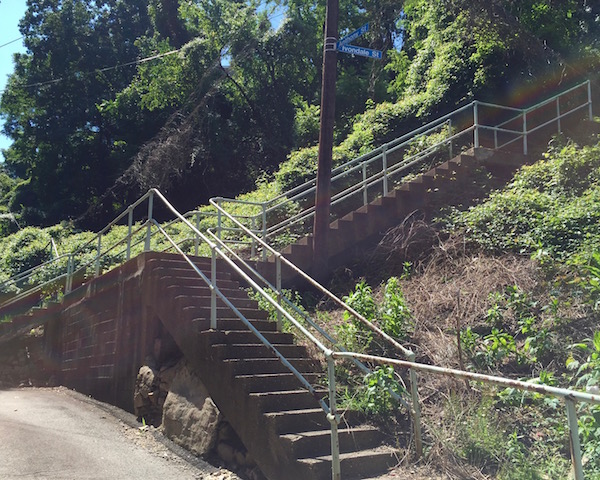
The other obvious factor on any step-trekker’s noodle is that this particular pair of step-streets is almost surely on the endangered list. At one time, Anthony Street must have continued all the way up the hill to Greenfield*. That would have connected residents of The Run up to Greenfield’s commercial district and uphill parishioners down to the mighty St. John Chrysostom Byzantine Catholic Church.

But those aren’t really well-travelled routes any more–at least, not on foot. In fact, they’re so neglected that you can only walk a tiny minority of Anthony Street before you’re met by an ocean of out-of-control overgrowth that completely blocks passage on the through-way**.

city steps overgrown with weeds, Pittsburgh, PA

Pittsburgh Babylon: Anthony Street’s long, inaccessible climb up to Greenfield

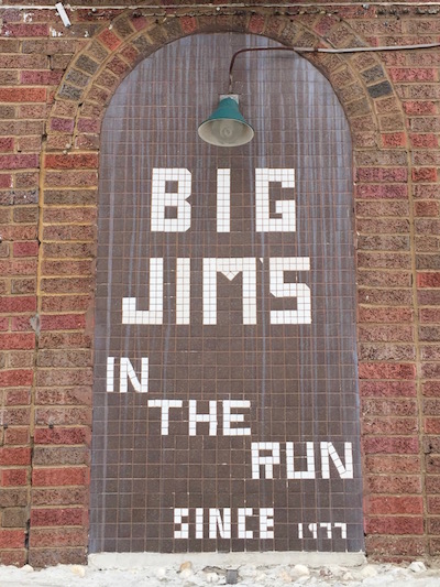
Anthony & Ivondale will never be destination steps like Rising Main or Little Jewel Street or the “Try Try Try” steps. But if you find yourself in The Run for a large sandwich at Big Jim’s or just passing through en route between the Schenley Park and “Jail Trail” bicycle runs, it’s well worth the stop and poke-see. You won’t get lost; there’s nowhere to go.


* Looking at the map, it seems like Anthony probably terminated at tiny Raff Street, itself just an extension of Alger Street, a block off Greenfield Ave.
** Already on the list is going back in the winter when we can see what’s left when the knotweed has died off.

Egg Hunt

front yard display with Easter bunnies and eggs, Pittsburgh, PA

Lawrenceville

The bunny and the egg. That the high Christian holiday of Easter would be associated with two such non-religious totems seems strange. However it happened, we ended up with the bunny (always white; never a “rabbit”) and egg (brightly colored; sometimes elaborately decorated) as the emblems of the season. Eggs kind of make sense–Easter is either the celebration Jesus’ resurrection (if you’re Christian) or the spring holiday (if you’re pagan), and eggs certainly represent the spirit of rebirth (really, new birth) as well as anything. Bunnies? Not so obvious.

rowhouse window with Easter bunnies and eggs, Pittsburgh, PA

Bloomfield

This blogger grew up in The South and though my memory is foggy, I don’t ever remember Easter being as big a deal–and I really don’t remember people decorating their houses the way Pittsburghers do. The variance is minimal and it’s basically all store-bought, but there’s a lot of it.

De rigueur are plastic colored eggs in both chicken and dinosaur sizes, sometimes strung on lines or hung from trees, often just resting in a front patch of grass or nestled under shrubs. Occasionally these come in a light-up strand like Christmas lights. You’ll often see die cut two-dimensional paper eggs pasted into windows and taped on door frames.

The other nearly as common element is the white Easter bunny. These creatures vary from hefty ceramic hand-painted garden centerpieces to plastic stand-up figures to fuzzy paper decorations that look like flat piñatas.

small flowering tree with plastic Easter eggs, Pittsburgh, PA

Bloomfield

It strikes me that the palette is so slim. Just two images–plus the occasional flower, cross, or duckling thrown in as garnish–for such an important holiday. Compare this to Christians’ other big day: Mary, Joseph, the little lord Jesus, wise men, yonder star, the manger, Santa, elves, the sleigh, reindeer, presents, candles, candy, carolers–the list goes on and on. Christmas also gets its own defined color scheme, song book, and yearly television specials. I’m sure there are traditional Easter church hymns, but what about carols?

sidewalk chalk drawing of Easter egg, Pittsburgh, PA

The Run

This year, Easter Sunday rolled around and this heathen had neither a church service nor holiday ham supper to look forward to. So with a glorious seventy degrees and cloudless blue skies The Orbit set out on an old school egg hunt.

We weren’t actually out to possess any eggs. We just wanted to get an idea of who was out there decorating and what they were doing with the eggs. Of course, we’ll also take any excuse to ride the Orbit-cycle for a couple hours and poke our nebby Orbit-schnozes into other people’s business–and believe you me: schnozes were poked in the making of this story.

plastic Easter eggs hanging from tree, Pittsburgh, PA

Bloomfield

The ride took us all over the place–The Strip, Spring Garden, Central North Side, downtown, South Side, The Run, Panther Hollow, etc.–but observant Orbit readers will note that almost all these photos came from just two neighborhoods: Bloomfield and Lawrenceville.

Are these places Easter central? Maybe. Or did we just poke a little harder or a little wiser in the well-known nearby terrain? Well, that’s believable too. We definitely had insider information on the Easter crazy pair of neighbors on Lorigan Street in Bloomfield that generated several of these pictures.

tree with garland of plastic Easter eggs, Pittsburgh, PA

Lawrenceville

Along the way, we ran into one legitimate kid-centric egg hunt taking place in Arsenal Park. These eggs were not well-concealed–I must have spotted two dozen from the seat of my in-motion bicycle–but the target age of participants seems to start at the just-barely-walking, so I suppose it’s a fair contest.

The whole experience was good fun and good exercise and got us thinking that it might be interesting to stage an Orbit-sponsored, bicycle-based egg hunt for next year’s holiday. Would folks be into that? I don’t know, but maybe we’ll give it a try next year.

window flower box display with bunnies and eggs, Pittsburgh, PA

Bloomfield

rowhouse windows decorated with Easter bunnies and eggs, Pittsburgh, PA

Lawrenceville

front stoop display of Easter bunny and eggs

Lawrenceville

Pittsburgh’s Next Hottest Neighborhoods

older frame houses with clear blue sky and bare trees, Pittsburgh, PA

Allentown rooftops, just around the corner from NoCarSoSoSlo

Pittsburgh is famously a city of neighborhoods–ninety of them, to be exact. Most are incredibly distinct. There’s no questioning the transition from Bloomfield to Oakland or Larimer to Lincoln or Polish Hill to Lawrenceville–you have to cross a bridge to get there. Spring Hill and Troy Hill are way up on the top of steep hills; Spring Garden is down in the valley between. More subtley, Bloomfield and Friendship are on the same plane, but as Friendship Ave. dog-legs around, the street grid changes bias, the blocks change dimension, and Friendship’s stately detached homes yield to tight Bloomfield aluminum-clad row houses. It’s clear you’re somewhere else.

But not all of the city is as well-defined, nor is it all prospering at the same rate. What to do? Enter the acroname–the citizen and/or developer-based rebranding of urban spaces to upsell low-rent sections of town into yuppie havens and “whitopias”. New York has famously come up with SoHoTriBeCaNoLita, Dumbo, etc. to address this; others have followed suit. Pittsburgh has been blessedly free of this trend*, but at the rate we’re gentrifying–and our collective me too obsession–it seems like it’s only a matter of time.

Here then is an Orbit modest prediction/proposal for the rebranding of some parts of town that are maybe a little harder to define just how and where they fit in.

NoSOak (“No Soak”)

row homes in Pittsburgh, PA

Empty beer bottles, an American flag in the window: that looks like NoSOak to me

The residential section of central Oakland, with Bates as its main through street, was traditionally an Italian-American neighborhood, but that legacy has largely ceded to college ghetto. Ratty old couches fill front porches , flags and beer signage decorate dirty windows. By rebranding itself NoSOak (North of South Oakland), the neighborhood’s landlords and property developers may be able to usher in an entirely new clientele of tech yuppies and hospital workers, eager to rehab those turn-of-the-century row houses on pedestrian-friendly blocks, the lovely aroma of street tacos perpetually wafting in the breeze.

NoCarSoSoSlo (“No Car–So, So Slow”)

Detail from the hand-painted storefront of the Mount Oliver Mens Shop, Pittsburgh, PA

The Mens Shop, a NoCarSoSoSlo icon for generations

The southern borough of Mount Oliver is a politically-independent island entirely surrounded by the city of Pittsburgh, but hasn’t benefitted from (or gotten ruined-by–take your pick) the rapid gentrification that so much of the city is experiencing. Heck, even hilltop neighbor Allentown has a heavy metal coffee shop now! With the rebranding NoCarSoSoSlo (North of Carrick/South of the Southside Slopes) the borough can reference two city neighborhoods without ever mentioning you have to pay goofy Mount Oliver taxes.

VoBeShaBlo (“VO-bee-shay-blow”)

older frame houses, train tracks, and busway, Pittsburgh, PA

View of VoBeShaBlo through the chain link fence of the Aiken Ave. Bridge

The two-to-three-block-wide strip that runs between the train tracks/east busway and Baum Boulevard are technically Shadyside, but it’s physically cut off from the heart of that neighborhood and it doesn’t share its hoity-toity feel. To mix our metaphors like we’re real urban planners, VoBeShaBlo (The Void Between Shadyside and Bloomfield) is a line in the sand that its resident “Shay-Blowers” will wear with pride, finally attaining an identity that’s been missing for a long, long time.

The hoodlet has some appealing (potential) amenities that can make this work. There are nice, if not fancy, older frame houses (although not that many of them). Between Centre and Baum they’ve got a bigger business district than a lot of city neighborhoods. And it’s well-connected/located if you’re either a cyclist or bus rider. VoBeShaBlo’s Giant Eagle even sells beer!

PaHolE / WheBiJIs (“PAY-hole / we-BIJ-iss”)

Tile sign for Big Jim's in The Run, Pittsburgh, PA

Big Jim’s, a PaHolE / WheBiJIs institution since 1977

Four Mile Run, or just “The Run”, is the tiny sub-neighborhood under both The Parkway and Swinburne bridges. Its technically a part of Greenfield, but doesn’t really feel like it. Like Rodney Dangerfield, a lot of people go back to school via its walk/bicycle path directly to central Oakland and cyclists know it as the connection point to the jail trail. But with literally just one-way-in/one-way-out, motorists typically ignore it and most of Pittsburgh has probably never even been to the neighborhood.

Luckily for PaHolE / WheBiJIs (Panther Hollow East / Where Big Jim’s Is) there are a couple of great local places of note including the great St. John Byzantine Church, access to the Schenley Park ball fields, city steps up to Greenfield proper, and Big Jim’s terrific eponymous tavern. Let’s quit fooling around and put it on the map.

HiDiBuNoQuOak (“HI-dee-boo-no-quoke”)

View down Dunsieth Street, Pittsburgh, PA

Looking down Dunsieth Street toward Carlow University in HiDiBuNoQuOak

The area around Pitt’s upper campus doesn’t really feel like it fits in anywhere. It’s the university, so that’s Oakland, right? But it’s also way up the hill–at the southeastern edge of The Hill District–physically separated from the hospitals and school buildings below. By embracing their new identity as HiDiBuNoQuOak (Hill District, But Not Quite Oakland) residents tell the world they’re doing their own thing in their own time, man. No quoke.


LoLa (Lower Lawrenceville) and Eastside (East Liberty adjoining Shadyside) are the two painfully obvious exceptions, although The Orbit doesn’t know anyone that actually uses these terms.